| San Francisco Bay | A Brief History of Richmond | |
|
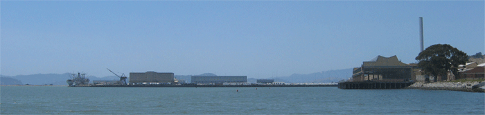
This whole shoreline was marshland through the period of Spanish settlement. Point Richmond was an Island. The Cochiyunes tribe of the Ohlone people, hunted and fished here an estimated 5,000 years ago. These are the people who built shellmounds along the bay (one of which can still be seen below point Islabel). After Mexico won independence from Spain in 1821, large tracts of land in California were granted to military heroes and loyalists. In 1823, Don Francisco Castro was granted Rancho San Pablo. It was subdivided among the Castro offspring in 1856 and latter became the subject of much litigation among the Castro descendants. It was worth fighting about because it was over 5 square leagues or approximately 13 square miles. It adjoined the Peralta Grant on the north and roughly embraced what are now the towns of El Cerrito, Kensington and a large part of the present city of Richmond, and ran up San Pablo Canyon to the side of the San Pablo dam. Ellis Landing, Richmond's first maritime facility was established in 1860 at the foot of what is now Harbor Way. It operated for more than 40 years until the beginning of the 20th century, with sailing scows carrying farm produce to the City (San Francisco) and ferrying passengers back and forth across the Bay, but only when the tide was high enough to navigate through the mud flats. For a while after the Loma Prieta earthquake, a passenger ferry operated from the pier next to the Ford Plant. In 1899 Richmond attracted its first industry, the Santa Fe Railroad, largely on the basis of the claim that Point Richmond was "the only point on the east side of the Bay where land and navigable deep water meet.” Ferry Point became Santa Fe's western terminus. On July 3, 1900, the ferry “Ocean Wave” discharged the first passengers at Point Richmond’s Ferry Point to a waiting Chicago-bound train. Later on, the railway cars were loaded directly onto barges for the last leg of the trip to San Francisco. The building of the bridges killed off the ferry traffic all over the bay Terminal One, located near Point Richmond, operated as a port facility from the early 1900s until the late 1980s. It was primarily used as a storage and warehouse facility and for transfer of cargo and bulk liquids from ships to trucks and rail cars. There is still some break bulk shipping in and out of Richmond primarily of scrap metal and some chemicals. The largest operation appears to be shipment of cars which are transferred to trains here. Mostly the rise of the container ship (which requires vast amounts of space to store the containers) put an end to the dominance of the Port of San Francisco. Most of container traffic is handled out of Oakland. From left to right: Red Oak Victory, the "Whirely Crane, Kaiser shipyard #3 and the Ford Assembly Plant In 1901 Standard Oil began construction on the largest refinery on the Pacific Coast. Its wharf , refinery and storage facilities are still in operation and under the trust-busted fragment known as Chevron. You can see the Chevron Long Wharf and tanks here. Richmond was incorporated in 1905. By 1907 harbor construction was being promoted and major dredging and terminal construction was authorized by bond issues in 1912 and 1920. The coast line began to change quite dramatically . Ellis Landing (near where the Ford Plant is now) was filled in and the channel was dredged. In 1930 during the Great Depression, the Ford assembly plant was built measuring nearly 500,000 square feet and making Ford the third largest employer in the city of Richmond. This building was used in the filming of movie "Tucker". In 1940, the population of Richmond was 23,000. In 1941, the management of Todd-California was given a contract by the Maritime Commission to construct a yard to be known as Richmond #2 on marshland at current site of Marina Bay. Operating under the name "Richmond Shipbuilding Corporation", a subsidiary of Kaiser's Permanerite Metals Corporation, Kaiser was soon producing Liberty ships like the Jerimiah O'Brian (now berthed at Pier 45 in San Francisco but built in Maine) . In 1944, production began on Victory ships like Red Oak Victory (now located alongside the drydocks at the former Richmond Yard #3 and which was actually built in Richmond).
President Franklin D. Roosevelt banned the production of civilian automobiles during WWII. The Richmond Ford Assembly Plant switched to assembling jeeps and to putting the finishing touches on tanks, half-tracked armored personnel carriers, armored cars and other military vehicles destined for the Pacific Theater. By July of 1942, military combat vehicles began flowing into the Richmond Ford plant to get final processing before being transported out the deep-water channel to the war zones. After the war, production of Fords resumed at the plant somewhat offsetting the sudden job loss caused by the cessation of ship production. The last Ford was assembled in February 1953, with the plant being closed in 1956. Most of the damage you see was caused by the Loma Prieta Earthquake of 1986. By 1943, the population of Richmond was over 100,000 souls lured by the jobs made available by the war boom and the departure of the white men for military service overseas. In the 50's, 60's and 70's, Richmond was "redeveloped" and cut through with freeways and the population both declined adn became poorer. The war and industry have left a legacy of poor infrastructure, substandard housing (except along the bay) and tremendous pollution. Richmond is beginning to recover some middle class housing (often over the objections of Chevron) mostly along the water front as the rest of the Bay Area has become very expensive. Richmond seems to be on the upswing with a very lively historical district just inside the tunnel behind Ferry Point in Point Richmond. Unfortunately that area is a little too far to walk to from the docks. |
| ©2002-6 Accidental Cruiser | Home • Islands • Photo Journal • Cruising Log • Sailing Info • Viewer's Comments • Comment |