|
|
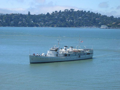
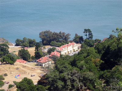
This view across Racoon Strait toward Tiburon shows the USS Potomac pulling in to the pier at Ayalay Cove. The USS Potomac was built in 1934 as the Coast Guard cutter Electra. The 165-foot vessel, weighing 376 gross tons and cruising at speeds of 10 to 13 knots, was commissioned as a U.S. Navy vessel in 1936, renamed the USS Potomac, and served as Franklin Delano Roosevelt’s presidential yacht until his death in 1945. The USS Potomac She is berthed in the Oakland Estuary at Jack London Square right next to the ferry pier. More information here
 In 1814, the British 26 gun sloop of war, the H.M.S. Racoon, was damaged off the coast of Oregon, but managed to stay afloat long enough to reach San Francisco Bay. From March 13 to 19th of that year, the ship was repaired on the beach at Ayala Cove. This event is commemorated by the name given to the deep water channel between Tiburon and Angel Island: Racoon Strait. The ship's presence here was an obscure side-note to the obscure war of 1812. In those days, business in the northwestern portion of this continent was dominated by the fur trade. Glass beads, axes and iron tools were exchanged for furs which were fashionable clothing in the rest of the world. In the east, the trade was dominated by the famous Hudson Bay Company. Out west, North West Company (based in Montreal) was much less known and successful. It was hampered by its lack of an exclusive charter to its area and by the fact it wasn't able to trade directly with China, a right reserved to the British East India Company. Accordingly, the North West Company had only a marginal hold on its Oregon holdings. John Jacob Astor, who, as an American, would not have to respect these British Royal limitations saw enormous opportunity. He could freely take fur from Oregon off to China and become even more rich. After some confused skirmishing, the North West Company persuaded the Crown to send help to defend their holdings in the west. The British sent ships whose captain and crew were motivated partially by the chance of wartime prize. Imagine Captian Black's disappointment after such a long journey to both damage his ship on the Columbia bar trying to capture Fort Astoria only to find the Fort had already become British by sale.
This paragraph was corrected by a GGGGrandson of a sailor aboard HMS Racoon in an email exchange, click here. In 1814, the British 26 gun sloop of war, the H.M.S. Racoon, was damaged off the coast of Oregon, but managed to stay afloat long enough to reach San Francisco Bay. From March 13 to 19th of that year, the ship was repaired on the beach at Ayala Cove. This event is commemorated by the name given to the deep water channel between Tiburon and Angel Island: Racoon Strait. The ship's presence here was an obscure side-note to the obscure war of 1812. In those days, business in the northwestern portion of this continent was dominated by the fur trade. Glass beads, axes and iron tools were exchanged for furs which were fashionable clothing in the rest of the world. In the east, the trade was dominated by the famous Hudson Bay Company. Out west, North West Company (based in Montreal) was much less known and successful. It was hampered by its lack of an exclusive charter to its area and by the fact it wasn't able to trade directly with China, a right reserved to the British East India Company. Accordingly, the North West Company had only a marginal hold on its Oregon holdings. John Jacob Astor, who, as an American, would not have to respect these British Royal limitations saw enormous opportunity. He could freely take fur from Oregon off to China and become even more rich. After some confused skirmishing, the North West Company persuaded the Crown to send help to defend their holdings in the west. The British sent ships whose captain and crew were motivated partially by the chance of wartime prize. Imagine Captian Black's disappointment after such a long journey to both damage his ship on the Columbia bar trying to capture Fort Astoria only to find the Fort had already become British by sale.
This paragraph was corrected by a GGGGrandson of a sailor aboard HMS Racoon in an email exchange, click here.
Angel Island
 In August of 1775, Lt Juan Manuel de Ayala brought his ship, the San Carlos, into the San Francisco Bay and anchored in what is now known as Ayala Cove. He made the first map of the Bay and named the island he anchored next to "Isla de Los Angeles" after the religious feast day closest to the island's discovery.The island was deeded to Antonio Oslo for use as a cattle ranch in 1837, but in the days after the war with Mexico, title was disputed and squatters moved in. The military took over the island amidst concerns that California might come under attack from Confederate sympathizers and naval forces in the American Civil war. Camp Reynolds (West Garrison) was established on Angel Island in 1863. Artillery batteries were built near the camp and
at Points Stuart, Knox, and Blunt. After the Civil War, Camp Reynolds
became an infantry camp, serving as a depot for recruits, and as a
staging area for troops serving in campaigns against the Apache, Sioux,
Modoc, and other Indian tribes. In 1886, a report critical of Pacific
Coast harbor defenses led to development of new gun batteries on the
southwest side of the island facing the Golden Gate. Batteries Ledyard,
Wallace, and Drew (the remains of which are visible today) were in
operation by 1904, The Island has been used by the Federal Government for every thing from immigration quarentine station for Asian immigrants to Nike nuclear missle base and is currently still in use by the Coast Guard. A good overview of the island's history is here. Much of the Island is currently a state park. In August of 1775, Lt Juan Manuel de Ayala brought his ship, the San Carlos, into the San Francisco Bay and anchored in what is now known as Ayala Cove. He made the first map of the Bay and named the island he anchored next to "Isla de Los Angeles" after the religious feast day closest to the island's discovery.The island was deeded to Antonio Oslo for use as a cattle ranch in 1837, but in the days after the war with Mexico, title was disputed and squatters moved in. The military took over the island amidst concerns that California might come under attack from Confederate sympathizers and naval forces in the American Civil war. Camp Reynolds (West Garrison) was established on Angel Island in 1863. Artillery batteries were built near the camp and
at Points Stuart, Knox, and Blunt. After the Civil War, Camp Reynolds
became an infantry camp, serving as a depot for recruits, and as a
staging area for troops serving in campaigns against the Apache, Sioux,
Modoc, and other Indian tribes. In 1886, a report critical of Pacific
Coast harbor defenses led to development of new gun batteries on the
southwest side of the island facing the Golden Gate. Batteries Ledyard,
Wallace, and Drew (the remains of which are visible today) were in
operation by 1904, The Island has been used by the Federal Government for every thing from immigration quarentine station for Asian immigrants to Nike nuclear missle base and is currently still in use by the Coast Guard. A good overview of the island's history is here. Much of the Island is currently a state park.
 In 1850, a quarry was developed on the island's east shore which operated until the 1920's creating the parade ground at Fort McDowell. Rock from the quarry was used to build (among other things) the prison at Alcatraz. Fort McDowell was first used in the Spanish American War in 1896. in 1899, when a quarantine station was built at Fort McDowell on the eastern end of the island. This new facility made it possible to isolate troops who had been exposed to contagious diseases while serving overseas in the Spanish-American War and the Philippine Insurrection 1910 and 1911, Fort McDowell was expand into a
major facility for receiving recruits and processing military personnel
for overseas assignment. Construction included a huge 600 man barracks,
a mess hall, and a hospital. During the next few years, this new
construction made Fort McDowell the world's largest and most elaborate
military induction center.
In 1850, a quarry was developed on the island's east shore which operated until the 1920's creating the parade ground at Fort McDowell. Rock from the quarry was used to build (among other things) the prison at Alcatraz. Fort McDowell was first used in the Spanish American War in 1896. in 1899, when a quarantine station was built at Fort McDowell on the eastern end of the island. This new facility made it possible to isolate troops who had been exposed to contagious diseases while serving overseas in the Spanish-American War and the Philippine Insurrection 1910 and 1911, Fort McDowell was expand into a
major facility for receiving recruits and processing military personnel
for overseas assignment. Construction included a huge 600 man barracks,
a mess hall, and a hospital. During the next few years, this new
construction made Fort McDowell the world's largest and most elaborate
military induction center.
In 1917, following the U.S. declaration of war on Germany, the facilities at Fort McDowell were put to heavy use. Even the area next to the Immigration Station North Garrison was pressed into service as a prison for "enemy aliens" (most of them German citizens), who had been arrested on board ships in West Coast harbors. These men were later transferred to permanent detention quarter in North Carolina. In WWII, soldiers were stationed on Angel Island before being shipped out to fight in the Pacific. Right now, the activity you see has to do with the development of a new ferry dock and tourist center which is to relieve some of the pressure on Ayala Cove.
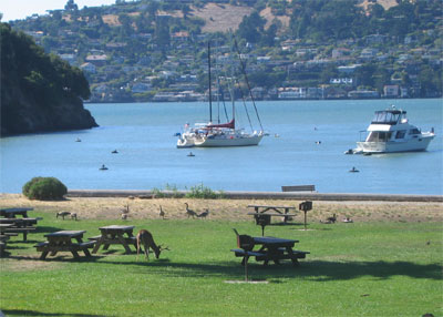
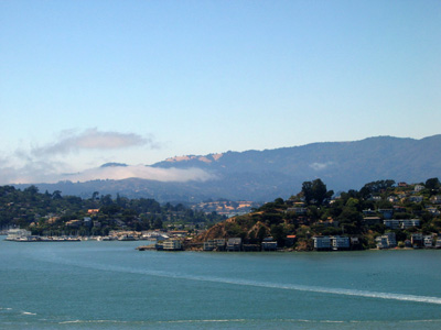 Tiburon is now home to some of the most expensive real estate in the country and is a delightful destination for sailors. There is a small dock at Sam's (just visible behind the point in the center and docking may be available at the Corinthian Yacht Club shown at left. The downtown is now a tourist destination.
Originally the Tiburon peninsula was home to at least fifty Indian villages and shell mounds, petroglyphs on the rock face of Ring Mountain and the occasional find of mortars are all that are left of the original inhabitants.
The Irishman John Reed established his ranch in 1834 on the lands where Mill Valley, Belvedere, Tiburon, San Quentin and Corte Madera are now. In addition to the usual cattle, he established salt yards, a brickyard and a stone quarry..
In 1884, Peter Donahue moved his terminal from Donaue's Landing in Petaluma to Point Tiburon as part of a southern expansion of the San Francisco and Northwest Pacific Railroad. Tiburon bacame a major railway depot with major ferry connections to San Francisco. Easy connection to San Francisco in turn inspired construction oft many summer homes of wealthy San Franciscans. Essentially 50 years after Reed, Tiburon became the empire of Peter Donahue who had branched from a San Francisco blacksmith's shop to the city's first foundary, the Union Iron Works, into transportation. He brought to Tiburon his SF&NP Railroad with frerry service from San Francisco and a rail line from Tiburon to San Rafael with stops as far north as Coverdale and eventually Eureka. There was a spirited rivalry between the SF&NP Railroad and the North Pacific Coast Railroad belonging to John Doherty and based in Sausalito. Races between the rival ferrys clearly contributed to the collision in 1886 bewtween Sausalito's San Rafael and Donahuse's Tiburon near the San Francsico Ferry Building.
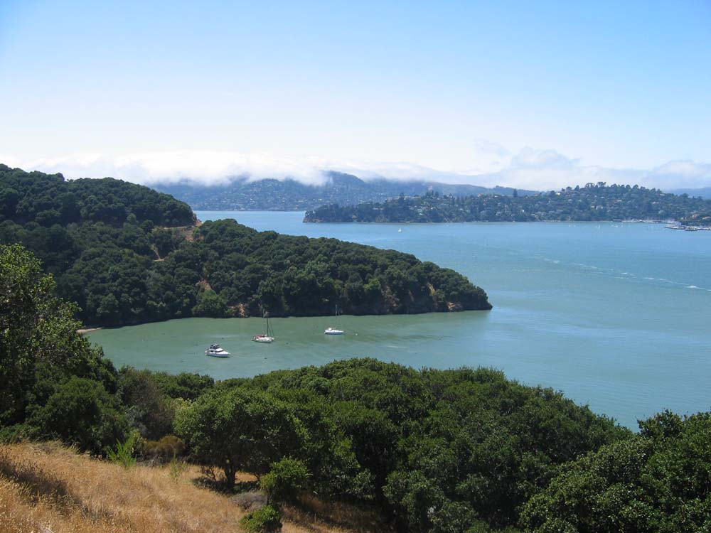
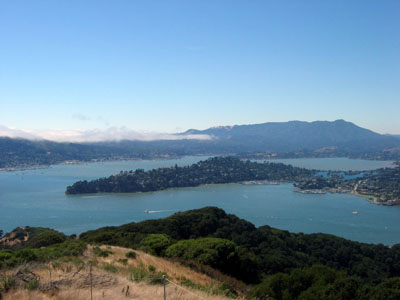 Belvedere is the highest income city in California and also number one in the country if you exclude cities under 1,000 population. Developed by the Belvedere Land company , it was originally an Island well separated from the bustling railhead in Tiburon. At one time, it was possible to purchase necessities from vendors on a small business street. There are now no businesses on the former island. In the 1950's, the town was expanded to include the Lagoon (visible in the center just in front of Richardson's Bay) which now links it to Tiburon.
|